
We wanted to congratulate our lab members who recently graduated: Cade Gouin on getting a Master’s Degree in Geography and Finn Rimay on getting his Bachelors degree in Microbiology and Cell Science and graduating Summa Cum Laude with highest distinction!
New NSF grant to study human movement dynamics under hurricane threats
Dr. Yujie Hu and collaborators Dr. Leo Duan and Dr. George Michailidis have received a new grant from the National Science Foundation to conduct geospatial modeling and risk mitigation for human movement dynamics under hurricane threats.
More information about the project can be found here.
Bayesian inference using the proximal mapping: Uncertainty quantification under varying dimensionality
New article first published online: Journal of the American Statistical Association
ABSTRACT: In statistical applications, it is common to encounter parameters supported on a varying or unknown dimensional space. Examples include the fused lasso regression, the matrix recovery under an unknown low rank, etc. Despite the ease of obtaining a point estimate via optimization, it is much more challenging to quantify their uncertainty. In the Bayesian framework, a major difficulty is that if assigning the prior associated with a p-dimensional measure, then there is zero posterior probability on any lower-dimensional subset with dimension d < p. To avoid this caveat, one needs to choose another dimension-selection prior on d, which often involves a highly combinatorial problem. To significantly reduce the modeling burden, we propose a new generative process for the prior: starting from a continuous random variable such as multivariate Gaussian, we transform it into a varying-dimensional space using the proximal mapping. This leads to a large class of new Bayesian models that can directly exploit the popular frequentist regularizations and their algorithms, such as the nuclear norm penalty and the alternating direction method of multipliers, while providing a principled and probabilistic uncertainty estimation. We show that this framework is well justified in the geometric measure theory, and enjoys a convenient posterior computation via the standard Hamiltonian Monte Carlo. We demonstrate its use in the analysis of the dynamic flow network data. Supplementary materials for this article are available online.
Dr. Yujie Hu joins the Editorial Board of Scientific Reports
Dr. Yujie Hu joins the Editorial Board of Scientific Reports.
Scientific Reports is an open access journal publishing original research from across all areas of the natural sciences, psychology, medicine and engineering.
More details about the journal can be found here.
Dr. Yujie Hu talks about commuting in the age of rising costs with WUSF Public Media
Dr. Yujie Hu was featured on the latest coverage Lack of affordable homes means longer commute times for more people in the Tampa metro area by Gabriella Paul at WUSF News.
Read the coverage here.
Dr. Yujie Hu joins the Editorial Board of Computers, Environment and Urban Systems
Dr. Yujie Hu joins the Editorial Board of Computers, Environment and Urban Systems.
Computers, Environment and Urban Systems is an interdisciplinary journal publishing cutting-edge and innovative computer-based research on urban systems, systems of cities, and built and natural environments , that privileges the geospatial perspective. The journal provides a stimulating presentation of perspectives, research developments, overviews of important new technologies and uses of major computational, information-based, and visualization innovations. Applied and theoretical contributions demonstrate the scope of computer-based analysis fostering a better understanding of urban systems, the synergistic relationships between built and natural environments, their spatial scope and their dynamics.
Application areas include infrastructure and facilities management, physical planning and urban design, land use and transportation, business and service planning, coupled human and natural systems, urban planning, socio-economic development, emergency response and hazards, and land and resource management. Examples of methodological approaches include decision support systems, geocomputation, spatial statistical analysis, complex systems and artificial intelligence, visual analytics and geovisualization, ubiquitous computing, and space-time simulation.
More details about the journal can be found here.
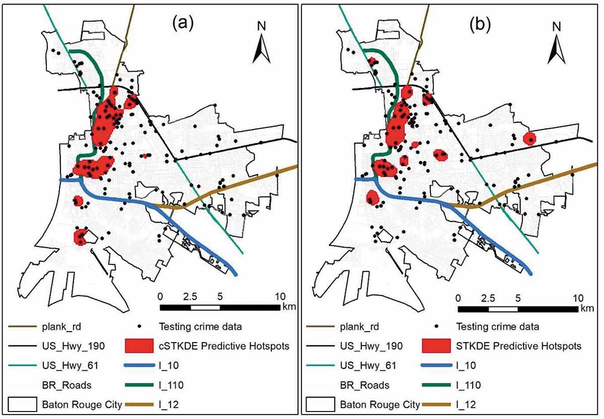
A cyclically adjusted spatio-temporal kernel density estimation method for predictive crime hotspot analysis
 New article first published online: Annals of GIS
ABSTRACT: This paper presents a new method for predictive crime hotspot analysis that further improves the kernel density estimation (KDE) method and the spatio-temporal kernel density estimation (STKDE) method by accounting for temporal crime cycles and is therefore termed the ‘cyclically adjusted STKDE (cSTKDE) method’. The case study on robbery incidents in Baton Rouge, Louisiana, shows a temporal cycle with a 6-month period of statistical significance from January 2010 to May 2018. This identified period is incorporated into the temporal kernel function of the new cSTKDE method. For validation, the Forecast Accuracy Index (FAI) and Forecast Precision Index (FPI) are used to evaluate the performance across 52 weeks in 2013. For 11 consecutive weeks since the beginning of 2013, the cSTKDE method outperforms the STKDE by 89% lower average abs(1-FAI) and 17% higher average FPI, and outperforms the KDE by 90% lower average abs(1-FAI) and 8% higher average FPI. Overall, the scenario with the best predictive accuracy by the cSTKDE is recommended over the traditional KDE or STKDE method as most feasible and effective in implementation of hotspot policing in practice.
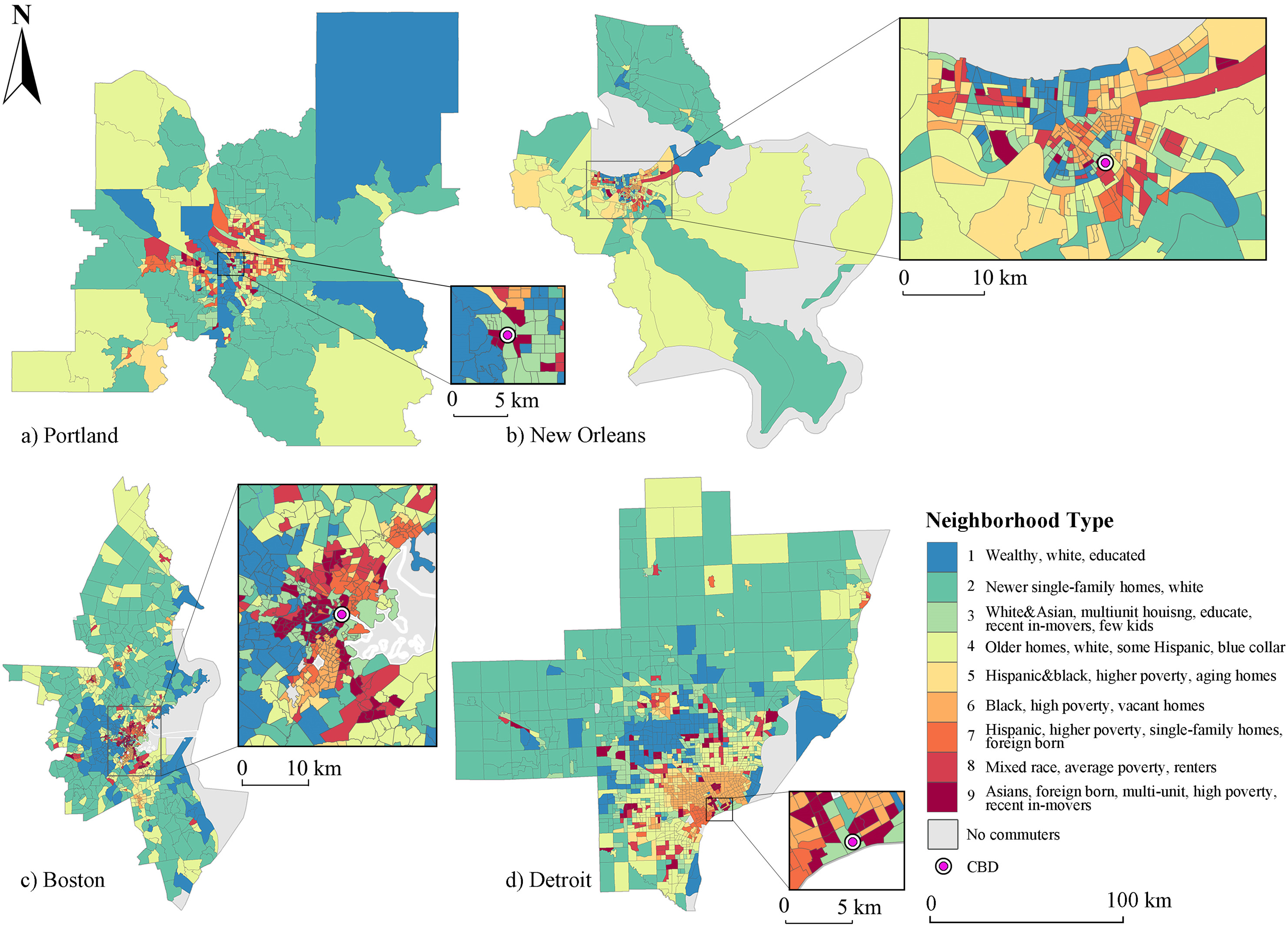
Neighborhood divides: Where you live matters for commuting and its efficiency
New article first published online: Cities
ABSTRACT: Excess commuting reflects a cits overall commuting efficiency by quantifying the proportion of non-optimal commute that would be avoided if resident workers could freely swap houses or jobs in a given urban form. This framework has been widely used to evaluate urban land use and transportation policy decision-makings. One major methodological limitation in the excess commuting literature is that most existing studies establish on an oversimplified assumption of homogeneous resident workers/jobs, which neglects the complexity of residential (and employment) location choices. To fill this gap, this research develops a methodology to measure excess commuting across worker subgroups differentiated by residential neighborhood type, which captures the comprehensive socioeconomic profiles of workers defined based on multiple attributes. Based on a cross-sectional study of Portland, Boston, New Orleans, and Detroit, it is found that the traditional method overestimates the commuting benchmarks and causes biased evaluation of commuting efficiency performance. Moreover, this research reveals significant disparities in excess commuting across different neighborhood types and identifies three representative subgroups of distinct excess commuting patterns, which are the traditional suburban subgroup, new starts subgroup, and socioeconomically disadvantaged subgroup. With this proposed methodology, more effective and heterogeneous policies targeting different population subgroups could be developed.
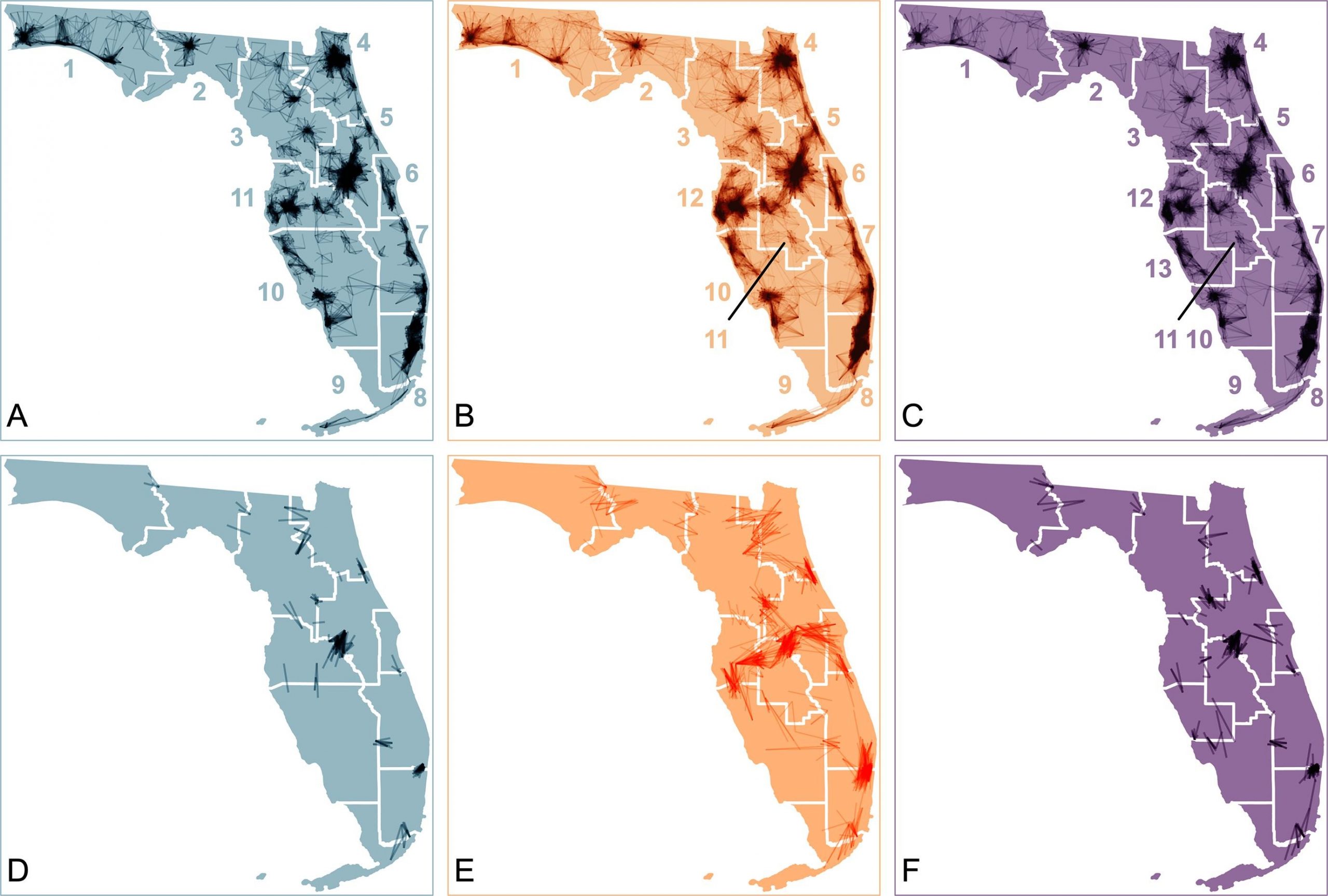
Delineating and comparing local labor market geographies of Millennials, Generation Xers, and Baby Boomers
New article first published online: Travel Behaviour and Society
ABSTRACT: There has been an increasing share of older workers in America’s workforce as Baby Boomers continue to age into this group. This raises questions about what their local labor markets look like in space and how they differ from Millennials and Generation Xers who are also active in today’s workforce. However, even though significant generational (or age) differences in commuting distance have been well documented, questions about generational disparities in local labor market geographies have not been investigated. Although several definitions of market areas exist, they were delineated using all commuting trips made by all workers in a region and thus may not be representative of subgroups of workers. The aim of this research is to delineate generation-specific local labor market areas and compare how they differ from one another. Using flow visualizations and three employment self-containment indices applied to a Longitudinal Employer-Household Dynamics dataset of Florida, this research finds that the core-based statistical areas, a popular definition of local labor market areas, understate the true market geographies across generational cohorts. It then delineates generation-specific market areas using a popular community detection method and compares their geographies using the self-containment indices. Results demonstrate largely consistent market geographies across the three generational cohorts in most regions in Florida. Most of these consistent market areas encompass two or more metros, indicating the emergence of functional megaregions centering on major metropolitan hubs. Substantial generational differences in market geographies do exist and concentrate in regions appealing to seniors along the Gulf of Mexico.
Enhancing the retail food environment index (RFEI) with neighborhood commuting patterns: A hybrid human−environment measure
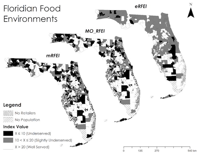
New article first published online: International Journal of Environmental Research and Public Health
ABSTRACT: The Retail Food Environment Index (RFEI) and its variants have been widely used in public health to measure people’s accessibility to healthy food. These indices are purely environmental as they only concern the geographic distribution of food retailers, but fail to include human factors, such as demographics, socio-economy, and mobility, which also shape the food environment. The exclusion of human factors limits the explanatory power of RFEIs in identifying neighborhoods of the greatest concern. In this study, we first proposed a hybrid approach to integrate human and environmental factors into the RFEI. We then demonstrated this approach by incorporating neighborhood commuting patterns into a traditional RFEI: we devised a multi-origin RFEI (MO_RFEI) that allows people to access food from both homes and workplaces, and further an enhanced RFEI (eRFEI) that allows people to access food with different transportation modes. We compared the traditional and proposed RFEIs in a case study of Florida, USA, and found that the eRFEI identified fewer and more clustered underserved populations, allowing policymakers to intervene more effectively. The eRFEI depicts more realistic human shopping behaviors and better represents the food environment. Our study enriches the literature by offering a new and generic approach for assimilating a neighborhood context into food environment measures.
